Plan for the first section of sector C of the bypass around Belgrade and Pancevo - Here's what will be built from Bubanj Potok to Bolec
Source: eKapija
 Thursday, 01.08.2024.
 09:37
09:37
 Thursday, 01.08.2024.
 09:37
09:37
Route location (Photo: Print screen / Zahtev za odlučivanje o potrebi procene uticaja na životnu sredinu / Putevi Srbije)

This ring road represents a key solution for transit traffic around the capital. By building a complete bypass road in this phase, transit traffic from the north (E-75) and west (E-70) would connect with the south (E-75) and east (E-70), as well as the future highway ( E-763) in the southwest direction, going around the city area. Only the highway directions are mentioned here, and there are main and regional roads in the area, which are connected or would be connected to the ring road.
The corridor in question passes through the Belgrade municipalities of Vozdovac and Grocka and the Pancevo industrial zone and includes:
- the new highway section from Bubanj Potok (on the right bank of the Danube) to state roads and local roads around Pancevo (on the left bank of the Danube);
- bypass freight railway Beli Potok - Vinca - Pancevo, which separates from the existing railway Rakovica - Mala Krsna - Velika Plana, passes from the southern side of the industrial zone Pančevo and connects to the railway Pancevo - Vrsac - state border;
- a new road-railway bridge over the Danube.
The subject of the design of this part of the documentation is the construction of the first section of the highway from the Bubanj potok interchange to the Boleč interchange.
It is to be expected that, after the formation of sector C, the highway bypass will fully assume the role and prerogatives of the appropriate categorization of the European network, i.e. together with roads E-75 and E-70.
The section in question passes through the cadastral municipalities K.O. Beli Potok, K.O. Zuce, K.O. Bolec, K.O. Lestane, K.O. Kaludjerica and K.O. Ritopek.
The most significant buildings on the subject first section of sector C are:
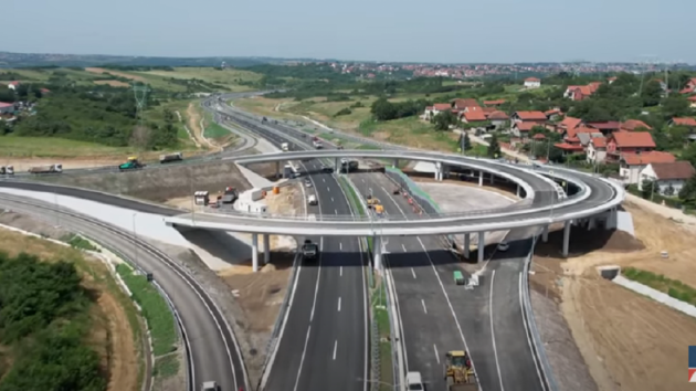
- uneven intersection (loop): Bolec;
- two tunnels: Bubanj potok and Lestane.
The Bolec loop connects the ring road with the IIA-order state road, No 153, in the continuation of the connection to Smeredevo.
The section in question begins at the end of the Bubanj potok interchange, which represents the intersection of the highway route through Belgrade and the part of the bypass around the city, i.e. with a continuation to the south of the country. In the future, once the construction of sector C is done, it will be a junction with the intersection of four highway branches. It is important to note that the mentioned loop was constructed to the full extent for the described future state.
The initial part of the route passes through hilly terrain, which is why there are two tunnels on the route - Bubanj potok and Lestane.
Immediately after the Bubanj potok loop, the homonymous tunnel name begins, with two tunnel tubes. The right tube should have three traffic lanes. The specified profile is maintained even after the tunnel, on the facility immediately following the tunnel, and only after passing it does it switch to the classic highway profile. The specificity of the left tunnel tube is that it mostly has two traffic lanes, while at the approach to the Bubanj potok loop, due to the position and characteristics of the constructed outlet for the Pancevo - Belgrade direction, the tunnel tube expands to a profile with three traffic lanes.
Read more:
- Continuation of project of construction of ring road around Belgrade – Environmental impact assessment to be done for sector C from Bubanj Potok to Pancevo
- Building Permit for Sector of Section C of Ring Road Around Belgrade from Bubanj Potok to Bolec in October
- Public Procurement for Project of Sector D of Ring Road around Belgrade Planned by April
Around 1,250 m after the Bubanj potok tunnel comes the Lestane tunnel, with a classic profile (two traffic lanes in each direction), while in the section between them there are three bridges on both sides of the highway route.
At about 1,650 m after the Lestane tunnel, comes the Bolec loop.
After the loop, the directions on the highway are separated, with the introduction of a bypass railway route between them, and this arrangement is also maintained on the bridge over the Danube. This zone is where the scope of the Conceptual solution ends.
The CIP Traffic Institute from Belgrade was in charge of the conceptual solution.
We remind our readers that the part of the ring road around Belgrade from Strazevica to Bubanj Potok was opened for traffic at the end of June last year.
A. K.
Tags:
E 70 highway
ypass around Belgrade and Pancevo
sector C
Beli Potok Vinča Pancevo bypass
bridge near Vinča
interchange Bubanj potok
Bolec
Beli Potok
Zuce
Lestane
Kaluđerica
Ritopek
Rakovica
Mala Krsna
Velika Plana
Comments
Your comment
Most Important News
Full information is available only to commercial users-subscribers and it is necessary to log in.
Follow the news, tenders, grants, legal regulations and reports on our portal.
Registracija na eKapiji vam omogućava pristup potpunim informacijama i dnevnom biltenu
Naš dnevni ekonomski bilten će stizati na vašu mejl adresu krajem svakog radnog dana. Bilteni su personalizovani prema interesovanjima svakog korisnika zasebno,
uz konsultacije sa našim ekspertima.


 Izdanje Srbija
 Serbische Ausgabe
 Izdanje BiH
 Izdanje Crna Gora


 News
News


